- Home
- Business
- Economic Development
- Location
Location
Location, Location, Location
Centrally located in the United States Barton County is strategically located to fit your business’ needs.
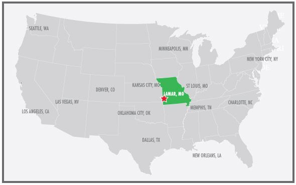 Distance from Lamar
- To Kansas City, MO: 120 Miles
- To St. Louis, MO: 300 Miles
- To Memphis, TN: 350 Miles
- To Dallas, TX: 400 Miles
- To Minneapolis, MN: 550 Miles
- To Denver, CO: 700 Miles
- To New Orleans: 750 Miles
Lamar & Barton County, Missouri Has Access To 3 Major US Highways
- Interstate 49
- Interstate 44
- US Highway 160
2 hours North to Kansas City, MO connects to I-29, I-35 and I-70.
Less than 1 hour South to I-44 connects to Oklahoma City, Joplin MO, Springfield MO, Saint Louis, MO and Chicago, IL.
Lamar & Barton County Intersects 3 Railways
Barton County is one of the nations’ newest Certified Work Ready Communities (CWRC). Barton County joined the first 100 counties in the U.S. to attain CWRC, which includes neighboring counties in the Joplin economic region as well as the Interstate 49 corridor.